Monday, April 29, 2019

The "Why" of Hills and Dales

Understanding landforms -- hills, dales, beaches, rivers -- is fundamental to understanding geography. Everything we encounter on the land is the result of processes -- fast, slow, expansive or local -- that are constantly reshaping the surface.

Our own Dr. Sandy Clark is an expert in geomorphology, which is the specialty with in geography that studies these processes. Those who study geomorph -- sometimes called the "geology of the last million years" -- will never look at the land around them in the same way. We are very fortunate that she will be offering Earth Surface Processes as a field-based course in Fall 2019. 

Click image to expand
This course requires an extra commitment of time, but that time will be rewarded with a lifetime of memories as students explore the White Mountains and Cape Cod on two separate excursions. Even if you know one or the other of these fascinating places, the exploration will reveal much about the "why" behind the "what" you have been seeing. More importantly, throughout the course you will learn new ways of understanding every landscape you encounter from now on.

Note: the Grand Canyon is shown on the course flier even though the fieldwork does not go quite that far from campus, because it is in the region where Dr. Clark gained her expertise, as a graduate student and river guide. Learning about the Colorado Plateau from her is the next best thing to being there!

Friday, April 12, 2019

Major Improvements

The Department of Geography is pleased to announce the final approval of four new concentrations in geography at BSU. After an extensive process of internal review, external review, further internal discussion, and working with campus-wide governance and Academic Affairs, we are pleased to announce that all newly declared majors will have four options, each tailored to particular facets of the intellectual and professional life of geographers.
Mandela Fellows from throughout Africa visiting the department's
EarthView and Africa floor map.
Map & photo: BSU alum Kevin Bean.
As in the past, all of our majors will complete a common set of course requirements, which serves to provide a common grounding in the discipline and ample opportunity to develop professional and personal connections with other geographers. All four concentrations also require study of a foreign language through the equivalent of a third-semester course.

The concentrations are: 

This concentration meets the needs of students seeking careers in government, business and non-profit organizations and for students who wish to pursue a graduate degree in geography. An appropriate sequence of courses enables students to acquire a geographic perspective and the spatial interdependence of human and environmental phenomena.

This concentration prepares students seeking careers related to environmental policy, climate change or urban planning and in pursuit of graduate degrees in geography. Emphasis is on social-science based understanding of climate change issues, climate justice, policy, mitigation and adaptation, as well as environmental issues and environmental policies and a foundational understanding of physical geography and climatology. Students will address the vulnerability that communities, states and countries currently have with regards to the environmental consequences of climate change. An appropriate sequence of courses enables students to acquire an appreciation of the challenges engaging in and communicating sustainable solutions and climate resiliency.

This concentration offers a balanced view of political, economic, social and cultural connections. Policy and geographic advantages and disadvantages impact citizens’ economic well-being and quality of life. In its broadest scope, development includes advances in social justice (such as women’s and minority rights, education and access to healthcare), and in economic progress (such as equitable distribution of income, access to employment opportunities and improvements to infrastructure). The degree offers exceptional preparation in the human-environmental framework of geography toward a critical worldview for anyone considering a career in globally-connected non-profit groups, non-governmental organization, or US or foreign government agencies or businesses effecting change on local, regional and national development problems.

This concentration combine rigorous preparation in human, physical and regional geography with coursework that focuses on the cultivation of geographically-informed learners. although its roots are found in ancient Greece, geography is an ideal way to learn about the modern world. Students of geography practice both a social science and a natural science, while learning to use mapping and geoprocessing to better understand and communicate about local,regional or global problems. As a broad, integrative discipline, geography is ideal preparation for classroom teachers, including generalists in the lower grades and social studies or earth science teachers in higher grades. Students who wish to be elementary teachers are required to double major in Elementary Education. Students should also refer to the Educator Preparation and Licensure Policies and Procedures section of the catalog for specific licensure and major requirements.

Lagniappe

The department has also recently proposed new academic minors; these have also been approved by university governance and will soon be published. Watch this space, the course catalog, and Degree Works for details.

Monday, May 28, 2018

Resilience

Writing in the Los Angeles Times, long-time public-radio reporter Elizabeth Arnold has issued a challenge to her fellow journalist. Having pivoted away from one form of false balance in climate-change reporting (which used to provide equal treatment to mainstream and fringe science), she suggests adjusting balance in a different aspect of reporting on the topic. A different balance needs to be found, she suggests, between reporting on the perils of climate change and reporting on remedies.
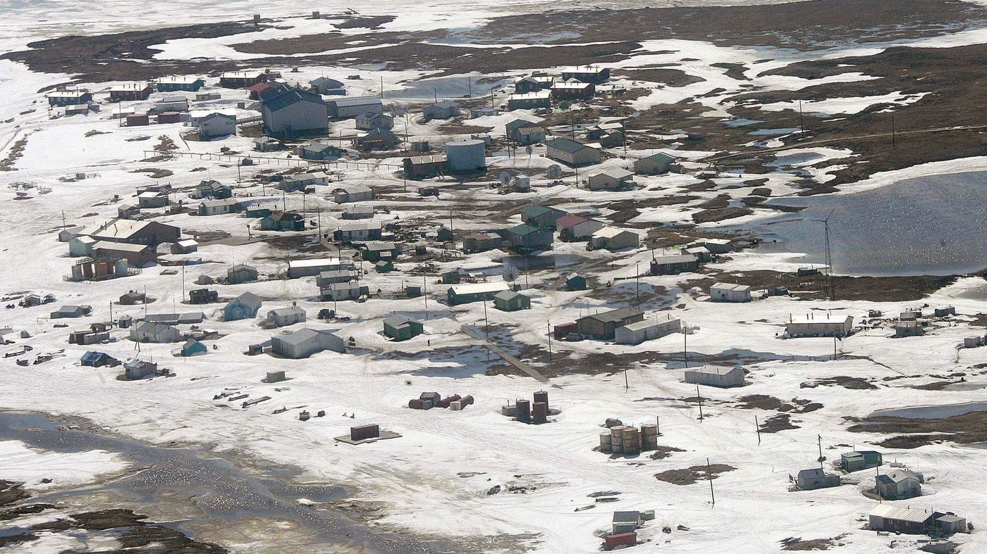
Newtok, Alaska has been the subject of much negative -- and true -- reporting about climate change. One of those reporters is urging her colleagues to report on the steps Newtok residents and their allies are taking toward resilience and remedies.
I read Arnold's essay while visiting Maryland, where the beloved historic district of Ellicott City was devastated by a "1,000-year flood" for the second time in two years. Clearly, it is a place where resilience efforts are not keeping up with changes in land use and the climate.

The keyword in her essay is the same one used in a new degree program that our department recently submitted for university approval: Resilience. The title of our proposed new concentration is Environmental Sustainability and Climate Resilience. In addition to courses in human, physical, and environmental geography, the proposed concentration will include courses in communications, natural sciences, and global languages.

It is an ambitious proposal, but one that we think will position our future graduates to rise to the challenge that Dr. Mary Robinson issued to geographers upon receipt of the AAG Atlas Award. In asking us to take up the challenge of climate justice, the former president of Ireland and human-rights commissioner said, "You understand how our planet works."

Pivoting our program more squarely in the direction of the growing resilience movement is a direct response to that challenge, and to the one posed by Elizabeth Arnold.

Lagniappe

Stay tuned, GeoBears, for more information about the resilience program and three others we recently submitted for approval:

Geography and International Development BA
Applied Geography BS
Geography for Educators BA

Two of these are relatively minor changes to our existing programs, while the other two are substantially new programs. All of the changes result from careful review over a period of several years, including input from experts, students, and alumni. All four programs will require study of a global language (currently Spanish, Portuguese, or Japanese). We have submitted all of the programs for review by university governance committees during the Fall 2019 semester, with the hopes of implementing them in 2020.

Monday, April 17, 2017

Summer Geography Reading

Suggestions for Becoming a Better Writer and A Better Geographer
IN ANY SEASON
-- by Dr. Hayes-Bohanan

As I have written on my "Writing Tips" page, "Good writing is the best evidence of clear thinking. It is also hard work." Good writing is not just the avoidance of grammar and style errors, though this is important, and a long list of examples was the first resource for students that I put online, in the 1990s.

Another section of my writing pages provides broader suggestions for becoming a better writer, which can be reduced to one word: READ. Late last year, I shared a short video of the venerable Rep. John Lewis, who shares exactly that admonition with all who will listen, as he knows it is both a benefit of and a prerequisite for liberty: JUST READ.

This post is in response to a general observation as I reach writing-intensive courses. A lot of our geography majors are, sadly, not avid readers. This is revealed by limitations of vocabulary and sentence structure that have only one cure: READING. 

As the semester winds down, I want to encourage our majors -- and our alumni and other friends of geography -- to do some serious, geography-related reading this summer. In addition to the suggestions above, this is inspired by a list of a baker's dozen geography titles from the article 13 Books About the Influence of Geography in Our Everyday Lives, which appeared recently on Signature, a web site that promotes reading as a tool of informed citizenry by posting short lists of good books on important topics. 

I have read a few of these and have put them all on my Goodreads list, where I will add reviews as I complete some of them over the summer. (That list already includes my reviews of about 20 other books.) In other words, I'm issuing myself the same challenge I'm giving to our students: READ!

I like this list from Signature because it is eclectic and the books included reinforce a basic idea that all geographers know: Place Matters. As I am certain some of my reviews will mention -- based on what I know so far of a few of the titles -- a few of the books stray a bit farther into the environmental determinism camp than I am comfortable with. But reading disparate ideas about place and causation makes us better geographers, so I will be reading from all parts of this list.

In addition to all of the recommendations above, I strongly encourage geographers to explore the book suggestions included in my favorite librarian's Celebrating the States blog. She spent 2010 honoring each of the 50 United States (plus some territories) by reading a book, watching a film, and preparing some food related to that state. I read a few of the books with her, watched most of the films, and helped to eat and/or prepare most of the food. Among the 50-plus titles she lists will be something for every geographer. 

Lagniappe

Two blogs that came in the wake of this one may also be of interest. In "Library" Books, she writes about books that mention libraries; in Nueva Receta Cada Semana, we both blog about foods that we prepare in our home.

Wednesday, April 5, 2017

EarthView at the State House -- Wed April 19

Photo credit: BSU Geography alumna Ashley (Costa) Harris
This iconic photo appears in Geography for LifeThe National Geography Standards from AAG/NGS/NCGE
Project EarthView -- a joint project of our Department of Geography, the Massachusetts Geographic Alliance, and the BSU Center for the Advancement of STEM Education -- is returning to the State House during Earth Week.

We have done this each April for almost a decade, as a way to celebrate and promote geographic education. The presence of a 20-foot portable globe inside the People's House has made a strong impression on many legislators, legislative staff members, April-vacation students, tourists from throughout the world who visit the Freedom Trail, and regional media outlets.

This year, we hope to have as many BSU students as possible -- from all majors -- join us at the State House. You can help us greet visitors to the globe itself, and you can also visit legislative offices to talk with legislators or their aides about the importance of geography education. Most of all, you can enjoy a day of learning in this fascinating building -- which has some interesting geographic characteristics and artifacts.

To organize this visit, we ask participants to enter our EarthView State House Doodle Poll and check one of three boxes. The first column is for those traveling in the van (capacity 12) that will deliver EarthView; the second is for the van leaving at 10:15 to accommodate students with early classes (capacity 15); the third is for people who will get to the State House on their own (marked 12pm, but you can come any time between 9 and 3).

Whether you can join us on April 19 or not, we hope that Massachusetts residents will contact their own representatives and senators to encourage them and members of their staff to visit EarthView. You can use the Find Your Legislator page to obtain a phone number and email address for such invitations.

REMEMBER: The State House is a secure facility with metal detectors and bag scanners. Prepare as if going to an airport.

Tuesday, December 6, 2016

Dunkin Donuts is Taking Over Weymouth

Founded by William Rosenthal in 1950 in Quincy, Massachusetts, Dunkin Donuts is a global donut and coffee company. Being based out of Quincy, it’s not unusual to see a store or two in surrounding towns like Braintree, Milton or Hingham for example. However, Weymouth tends to have not one.. not three.. but NINE different Dunkin Donuts locations!
            There are four sections of Weymouth: North (a.k.a N-Dub), East (a.k.a E-Dub), South (a.k.a S-Dub… just kidding, it’s just South), and Weymouth Landing (a.k.a the Landing). According to my map, there are at least two Dunkin Donuts locations in each section of Weymouth. Also, I noted the short distance between some of them, not just in miles but also in FEET! It's remarkable how many there are in such a short distance to each other.

            Now,  Bostonians in Weymouth have no need to drive to the nearest Dunkin Donuts locations. They just have to kick on their sneakers and walk to the nearest one, which is surely only a minimum 20-minute walk from every part of town! Or, they could save time and resources and brew their own coffee at home.


**Side-note: Sorry Dr. Hayes-Bohanan for mentioning Coffee Hell **

Thursday, December 1, 2016

South Dakota: A Far & Different Land From New England

Greetings Fellow Geographers,

For this map-blog assignment, I decided to create a map via Google Maps' 'My Maps' option and focus on South Dakota, a place I have not been to before, but will have the opportunity coming next spring.
My focus for this map was to highlight the American Indian reservation lands within South Dakota and plot  locations of interest that connect to these reservations and the Sioux Native American tribes.

Why choose South Dakota out of no-where you may ask? This past month I had applied and was accepted to participate in the BSU Community Service Center's Alternative Spring Break program, was of a lucky few picked to be a part of the ASB's trip to the Sioux YMCA in Dupree, South Dakota. This will be the first time I will be able to immerse myself within Native American culture, visit a reservation and also experience this part of the country. To help spread more information about the Sioux, reservations and the vast space of lands west of the Mississippi River, I thought creating a map to show where I'll be visiting next spring would be helpful. Considering most New Englanders are not familiar with most of the interior of the United States, I thought this map would be beneficial to my classmates.

The map has two layers, one that highlights the areas in South Dakota that myself and my small group of classmates who will be traveling with will mostly be aware of. The other highlights the other Sioux lands bounded in reservations today, as well as an outline of what was the "Great Sioux Reservation", the first treaty-partitioned land made by the U.S. government in the late 19th century.

The first layer includes the Cheyenne River Reservation, the Sioux land my ASB group will visit and live within for the week of spring break. We will be located in the town of Dupree and serve at the Sioux YMCA, which are both located with individual markers. The town of Eagle Butte, just to the north is located, along with the Cheyenne River Cultural Center, which is the center of the reservation's administration.
The first layer also highlights the Standing Rock Reservation, which is another Sioux reservation land that borders Cheyenne River Reservation within South Dakota and continues into North Dakota. This land should be of some familiarity to most Americans, as there has been a substantial protest near the Sacred Stone Camp (also spotted on my map) for several months against a proposed oil pipeline that would affect sacred lands to the Sioux. I simply added these locations to help show the proximity of the two reservations.
The Black Hills and Badlands National Parks are plotted to show nearby non-Native attractions (although both are sacred to Native Americans) and the Mt. Rushmore & Crazy Horse Monuments. My ASB group may have time to visit one of these locations, or other natural attractions before we begin our service week.

I hope this map helps you learn more about South Dakota and the Sioux people! - SB